
In June 1915, measurements near Tucson, Arizona, captured two very different versions of the same desert afternoon. Just 0.4 centimetres beneath the soil surface, the temperature reached 71.5°C. In the air four feet above it, the reading was 42.5°C. NASA recounts those observations in its explanation of land temperature versus air temperature.
Both readings were real. They described different parts of a landscape exchanging energy at different rates. That distinction is also the starting point for understanding a desert after sunset: the ground, the air touching it and the air above do not cool as one uniform object.
A hot afternoon can be followed by a surprisingly cold night. But “deserts are freezing after dark” is not a rule. What matters is how much energy the surface loses, how much it receives, and how readily the surrounding ground and air replace that loss.
Sunset changes the balance
The ground gives off thermal infrared radiation, invisible light that carries energy away. It does this during the day as well as at night. It does not wait for darkness to release energy. During daylight, absorbed sunlight can more than compensate for the losses. After sunset, that solar contribution disappears, while infrared emission continues.
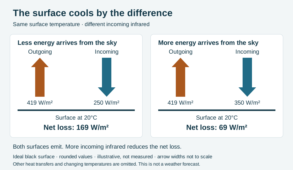
The atmosphere also radiates towards the ground. Water vapour, carbon dioxide and clouds absorb and emit infrared at relevant wavelengths; some surface radiation passes through the atmosphere to space. To find whether the ground cools, compare the energy leaving with the energy arriving. The difference is the net exchange. Giving off radiation alone does not tell us the result. NASA’s account of Earth’s energy budget explains these opposing flows. Its global averages should not be mistaken for the budget of one desert night.
An exposed surface can lose energy even when the air immediately above it is warmer. The Sun has stopped supplying the daytime input, but nothing has switched off the surface’s outward radiation.
A clear sky is not an empty sky
Dry, clear conditions often help the ground lose energy by radiation overnight. This process is called radiative cooling. Fewer water-vapour molecules along the radiation path generally mean less absorption and emission in their infrared bands. Clouds can increase the downward infrared reaching the surface, reducing its net radiative loss. That is one reason an overcast night can stay milder than an otherwise comparable clear one.
The familiar “cloud blanket” description has limits. A blanket mainly reduces heat transfer through moving air and conduction. A cloud’s role here is absorption and emission of radiation, not a solid lid stopping hot air. The Hong Kong Observatory’s radiation-cooling guide connects clear skies, light winds and dry conditions with pronounced surface cooling.
Nor does a dry atmosphere become transparent at every infrared wavelength. Carbon dioxide is still present, and radiation continues to arrive from the sky. Less incoming energy is different from none.
The ground has a thermal memory
Suppose two surfaces lose the same amount of energy. Heat capacity measures how much energy a material needs for a given temperature change. The surface with less available heat capacity cools more. But “available” matters: heat stored deeper down can replace the loss only as quickly as it moves through the ground. This transfer through material is called conduction.
Thermal inertia combines the effects of storing and conducting heat. A shallow layer of loose material can respond rapidly, while a surface well connected to a larger heat reservoir changes more slowly. NASA’s Jet Propulsion Laboratory explains thermal inertia in planetary terrain; the physical principle applies on Earth too, although that example concerns Mars.
This is why “sand cannot store heat” is the wrong explanation. Sand has heat capacity. The relevant questions are how much material participates, how well heat moves through it, and how much energy was stored earlier. A desert is not one uniform material with a single cooling rate.
Why the air near the ground follows
As the ground cools, it takes heat from the air touching it. On a calm night, the lowest air can become colder than the air above: a temperature inversion, reversing the familiar expectation that temperature decreases with height.
Wind can mix those layers. When warmer air is brought down towards a cold surface, the near-ground air may stay warmer than it would in calm conditions. This does not mean every windy night is mild. Wind can also transport a different air mass into the region, including much colder air. The National Weather Service’s explanation of nighttime temperature separates this transport from local mixing.
A forecast therefore needs more than the afternoon’s maximum and a desert label. It needs the developing cloud cover, wind and air mass, as well as the surface conditions.
Moisture works during the day, too
A large day-to-night temperature range is the difference between two endpoints. Conditions that reduce the daytime maximum can narrow that range without greatly changing the nighttime minimum.
Aiguo Dai, Kevin Trenberth and Thomas Karl examined this in a 1999 study using surface energy measurements and weather reports from roughly 6,500 stations. Their peer-reviewed analysis found that clouds strongly reduced daytime heating, while soil moisture contributed through evaporative cooling. Water vapour’s effect on the full daily range was comparatively small in their analysis.
That does not overturn radiative cooling. It shows why an explanation of one clear night should not become a universal explanation of every observed daily temperature range.
The calculation behind the interactive model
Cooling is not necessarily cold
Death Valley makes the distinction plain. The National Park Service’s climate guide describes summer overnight lows in the 90s Fahrenheit, around the mid-30s Celsius. A temperature can fall substantially and still remain hot.
Deserts are defined chiefly by their dryness, not a promise of either heat or freezing nights. The memorable change after sunset comes from an energy balance shifting beneath an open sky. To understand it, ask where the heat is going and what can bring it back.
EXPLORE THE IDEA
What slows the surface’s radiative cooling?
418.8 W/m²Outgoing infrared
168.8 W/m²Net radiative loss
-1.22 °C/hInstantaneous temperature tendency
Increase incoming infrared at fixed temperature: net loss falls. Increase heat capacity: the same loss changes temperature more slowly. A negative tendency means cooling; a positive one means warming in this radiation-only model. One kelvin of temperature change equals one degree Celsius.
Scroll the diagram sideways to see every label.
Illustrative instantaneous balance for an ideal black surface (infrared emissivity and absorptivity 1). Emission = σ(T + 273.15)⁴. Net loss = emission − incoming infrared. Temperature tendency = −net loss ÷ heat capacity per area, converted to °C/h. Inputs are not measurements. No sunlight, conduction from deeper ground, turbulent heat exchange, evaporation or evolving weather; this is not a forecast. No animation.
YOUR PERSPECTIVE
Join the discussion
What surprised you? Have a question or a correction? Share your thinking.
No comments yet. Start the conversation.
Sign in with ChatGPT to commentAnyone can read the discussion. Sign-in helps limit spam.