
A bright cumulus cloud can look solid enough to walk on. It may also contain hundreds of tonnes of liquid water. Put those facts together and the cloud seems to demand an invisible support: why does all that water not fall at once?
The answer begins by abandoning the picture of a cloud as a floating tank. A cloud is a vast region of air containing an enormous number of separate water droplets or ice particles. Gravity acts on every one of them, but their size, the drag of the air and the motion of the surrounding atmosphere decide what we see.
A cloud is mostly air
The white part of a cloud is not water vapour. Water vapour is a gas and is normally invisible. A cloud becomes visible after some vapour becomes liquid droplets or ice crystals that scatter sunlight.
Even a dark-looking cloud remains overwhelmingly air. NASA’s Global Precipitation Measurement team notes that dry air supplies almost all of a cloud’s mass; condensed water and precipitation usually contribute only a small fraction. NASA’s cloud and precipitation FAQ explains the mixture.
That distribution matters. The liquid is not gathered into one airborne lake. It is divided among microscopic particles and spread through an immense volume. Saying that a cloud contains a large total mass of water is therefore compatible with saying that each cubic metre contains very little.
A mass that sounds heavier than it is dense
Rising air creates the cloud
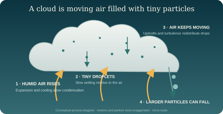
Cloud formation usually begins with air being lifted. It can rise because sunshine warms the surface, because terrain pushes wind upward, because air masses meet along a front, or because winds converge around low pressure. As the air rises, pressure decreases. The rising pocket of air expands and cools. If it reaches its dew point, the temperature at which its water vapour begins to condense, tiny droplets can form.
Condensation is easier on tiny airborne particles such as sea salt, dust or products of combustion. These cloud condensation nuclei provide surfaces on which droplets can begin. UCAR traces the sequence from rising air to cooling and condensation, while NASA explains why aerosols act as cloud seeds.
The apparently sharp base of a fair-weather cumulus cloud often marks the height where cooling makes condensation possible. Below it, the air can still take up more water vapour, so droplets evaporate. Above it, cooling has made condensation possible. The cloud is not an object placed at that height; it is the visible part of a moving stream of air.
Tiny drops have tiny settling speeds
A droplet is denser than air, so buoyancy alone cannot make it hover like a helium balloon. It does begin to fall relative to the nearby air. As the droplet speeds up, the air’s resistance, called drag, grows. Eventually drag balances its weight after allowing for the small upward buoyant force. It then approaches a terminal settling speed.
For a small spherical droplet in the low-speed regime, Stokes’ law says that settling speed grows with the square of radius. Using standard sea-level air properties, a droplet with a radius of 10 micrometres (one hundredth of a millimetre) settles at roughly 0.012 metre per second, or about 1.2 centimetres per second, in still air. Doubling its radius makes the idealised speed about four times larger.
That slow motion is easily matched by local upward currents. Turbulence also mixes droplets through rising, sinking and sideways eddies. A droplet can be falling relative to the air immediately around it while still moving upward relative to the ground because that air is rising faster. “Falling” and “going down” are not always the same statement unless the reference frame is specified.
The interactive model below isolates this competition. It is useful for micrometre-scale liquid droplets, not raindrops, ice crystals or a whole real cloud.
The cloud is continually being rebuilt
Cloud droplets do not need to remain in place for the cloud shape to persist. Moist air can enter, cool and create new droplets while other droplets evaporate into drier air at the edges. The visible boundary may appear steady even though air and water are passing through it.
Condensation also releases latent heat, energy that was taken in when liquid water became vapour. That energy can make a rising parcel warmer and more buoyant than it would otherwise have been, helping vigorous clouds continue to develop. NASA describes how condensation and latent heating participate in atmospheric ascent.
This dynamic view explains why a cloud can form over a mountain and seem almost stationary while wind crosses the summit. Air rises on the windward side, cools and becomes cloudy; farther downstream it descends, warms and the droplets evaporate. The pattern persists, but its constituent droplets are replaced.
When a cloud becomes rain
Small droplets do not stay small forever. In warm clouds, droplets of different sizes can collide and merge. This is called coalescence. In colder parts of clouds, ice crystals can grow while liquid droplets remain supercooled, still liquid below their usual freezing temperature, and several ice-phase routes can produce precipitation. NOAA describes collision–coalescence and ice-crystal growth.
As a liquid drop grows, its settling speed rises sharply. Eventually, particles become large enough that the cloud’s upward motion can no longer keep them aloft, and precipitation falls. NASA’s GPM explanation puts the transition plainly: cloud particles must grow and combine before they can overcome the supporting updraft. The same source notes that falling speed depends strongly on particle size. Explore NASA’s precipitation answers.
Rain is therefore not what happens when an entire cloud suddenly becomes too heavy. It is what happens when some particles within a cloud grow large enough to fall much faster through the air.
From naming shapes to explaining motion
Long before instruments could sample individual droplets, observers organised clouds by appearance. In December 1802, the pharmacist and amateur meteorologist Luke Howard proposed the Latin-rooted names cirrus, cumulus and stratus, then combined them for other forms. His scheme became the basis of modern cloud classification. The Royal Meteorological Society preserves Howard’s classification and descriptions.
Those names remain useful because form reflects process. A spreading layer, a heap growing upward and a fibrous ice cloud are not merely different pictures; they are evidence of different motions, temperatures and particle histories.
The next time a cloud seems to float, look for the process instead of the object. Countless droplets are responding to gravity, drag, turbulence, condensation and evaporation at once. The remarkable thing is not that water has escaped gravity. It is that water can be divided so finely, and the atmosphere can move so continuously, that falling becomes almost imperceptible until the cloud begins to rain.
EXPLORE THE IDEA
Will this droplet rise or descend?
0.012 m/sSettling relative to air
+0.038 m/sVertical speed relative to ground
Double the radius and the Stokes settling speed becomes four times larger. Increase the updraft to see how reference frame changes the result.
Scroll the diagram sideways to see every label.
Stokes-regime teaching model for an isolated spherical liquid droplet: v = 2(ρwater − ρair)gr²/(9μ), with fixed ρwater 1,000 kg/m³, ρair 1.2 kg/m³, g 9.81 m/s² and air viscosity 1.81×10⁻⁵ Pa·s. Inputs are illustrative, not observations. Valid here only for 5–40 µm radius droplets; omits turbulence, evaporation, condensation, collisions, ice, slip correction and changing atmospheric properties. No animation.
YOUR PERSPECTIVE
Join the discussion
What surprised you? Have a question or a correction? Share your thinking.
No comments yet. Start the conversation.
Sign in with ChatGPT to commentAnyone can read the discussion. Sign-in helps limit spam.