
A blue dot settles onto a street in Delhi. It feels as though something in orbit has found you and pointed down. That is almost the reverse of what happened.
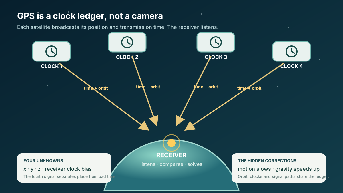
The satellites did not ask who you were. They did not receive your position. Each repeatedly broadcast a message containing where it was and when the message left. Your phone listened. From several travel times, it calculated where the listener must be.
There is a catch. Distance equals travel time multiplied by the speed of light, so an error of one microsecond, a millionth of a second, corresponds to nearly 300 metres of light travel. The satellites carry atomic clocks; a phone does not. GPS works by treating the receiver's bad clock as another unknown to solve.
The receiver therefore solves four things together: its east–west position, north–south position, height and clock error. Three numbers describe a place, and a fourth describes how wrong “now” is.
The satellites are lighthouses, not observers
Every GPS signal identifies its transmission time and supplies orbital information. A receiver compares the transmitted time with its reception time and multiplies the difference by the speed of light. The result is called a pseudorange, an apparent distance. It includes the actual satellite-to-receiver distance plus errors from the clocks and other effects.
One distance places the receiver on a sphere around a satellite. Further distances narrow the intersection. With a clock perfectly matched to GPS time, three suitable measurements could in principle solve the three position coordinates.
A phone’s clock is not that precise. Its inexpensive oscillator supplies regular timing ticks, but its error can exceed the signal’s travel time. A fourth satellite supplies another measurement. Together, four suitable measurements let the receiver solve longitude, latitude, altitude and clock bias, how far its clock is ahead or behind. Neil Ashby's technical review explains why four measurements determine three position components plus the local clock error. In practice, receivers usually use more signals and a richer error model.
The phone’s clock error affects all its measurements. Treating that shared error as an unknown lets the receiver calculate it along with position.
One clock error changes every apparent range
A flat teaching world with three fixed transmitters. A is at the upper left, B at the upper right and C below them. The small ring with a dark centre marks the receiver in both panels
1. If the receiver clock were matched
Circle radius = actual distance to that transmitter. All three circle edges pass through the marked receiver
2. The same receiver clock is ahead
Each apparent range = actual distance + the same clock-derived extra distance. Thin grey circles retain the original ranges for comparison
Solid navy circle: transmitter A’s range. Dashed teal: B’s. Dotted amber: C’s. The circle centres and drawing scale are unchanged between panels; the extra radius is identical for all three
- A range is a constraint
It places the listener somewhere on a circle in this flat analogy, or on a sphere in three dimensions
- The clock bias is shared
An ahead clock makes all ranges too long in this isolated example. A behind clock would make them too short
- Real GPS solves four unknowns together
Three spatial coordinates and one receiver-clock offset. Four suitable signals supply four measurements; real receivers also model other errors
A 2D distance-circle analogy, not to scale, satellite orbits or a GPS fix. The toy has two position coordinates plus one clock offset. Real GPS uses three spatial coordinates plus the receiver clock offset, requiring at least four suitably placed signals, with additional corrections and often more measurements. Circle enlargement does not forecast phone position error; the separate orbit model below is a clock-rate illustration.
Sources: NIST: broadcasts of satellite time and position; ESA Navipedia: pseudorange and the common receiver-clock term; ESA Navipedia: three position unknowns plus clock offset
An atom makes time into a ruler
The measurement still needs much better clocks in space. Atomic clocks do not count tiny mechanical ticks. Atoms can change between particular energy states. Electronics use the very stable frequency associated with one of those transitions as a timing reference. GPS satellites carry multiple atomic clocks, while ground control compares and corrects them against reference clocks. NIST describes the broadcast of satellite time and position and the continuing role of ground-based clock corrections.
The satellites therefore distribute more than coordinates. They distribute a shared time scale. GPS timing helps synchronize telecommunications, electrical networks and financial systems; GPS.gov calls time the system's fourth dimension.
But putting a precise clock in orbit creates a deeper problem. A clock is not outside physics. Its motion and the strength of gravity affect how quickly it ticks compared with a clock on the ground.
Two effects pull the clock in opposite directions
Special relativity says a moving clock accumulates less time than a clock at rest in the chosen reference frame. A GPS satellite travels at roughly 3.9 kilometres per second, so this motion effect makes its clock run slower than a comparable ground clock.
General relativity supplies the opposite sign. Gravity is weaker at the satellite's altitude than near Earth's surface, and a clock higher in the gravitational field accumulates more time. For a GPS-like circular orbit, this gravity effect is larger than the motion effect.
In the simplified comparison, gravity makes the satellite clock gain about +45.7 microseconds per day relative to the ground clock. Motion contributes about −7.2 microseconds per day, slowing it in the opposite direction. The net satellite clock gain is about +38.5 microseconds per day. Light travels roughly 11.5 kilometres in that interval. That indicates the scale of distance error. It does not predict a phone drifting exactly that far along a straight line. ESA notes that relativistic corrections can reach about 12 kilometres after a day.
What the orbit model can and cannot show
A satellite was allowed to disagree with Einstein
The correction was not installed merely because a famous theory demanded respect. Engineers created an experiment inside an early navigation satellite.
NTS-2, launched on 23 June 1977, carried the first caesium atomic clock placed in orbit. The system included a frequency synthesizer, electronics that could adjust the clock’s output to apply the predicted correction later. For about 20 days, the clock ran without it while engineers measured the rate. Ashby's review reports a measured difference of +442.5 parts in a trillion against a relativistic prediction of +446.5 parts in a trillion. The measured and predicted rates agreed at about the one-percent level. The synthesizer was then turned on.
This episode matters because it turns the slogan “GPS proves relativity” into something specific that engineers tested. The clock was allowed to be wrong in a controlled way. Its disagreement with ground clocks had a predicted sign and size. The result determined how the system should be operated.
The correction is a ledger, not one magic number
The +38.5-microsecond figure is the memorable entry, not the whole account. Real orbits are slightly eccentric, stretched rather than perfectly circular. Satellite speed and distance from Earth therefore change around the orbit, changing both relativistic effects. Broadcast navigation messages carry clock parameters, and receivers apply additional relativistic corrections. Ground stations track satellite orbits and clocks. Earth rotates while a signal travels. The ionosphere, an upper region containing charged particles, and the troposphere, the lower atmosphere where most weather occurs, delay radio waves. Buildings can reflect them. Satellite geometry changes how timing errors map into position.
That is why GPS accuracy is not a single property of “the satellite.” It is the result of a ledger in which orbit, clock, atmosphere, receiver and map each contribute corrections and uncertainty. ESA's navigation reference describes broadcast clock offsets and relativistic terms. Galileo similarly uses multiple space-qualified clock technologies and regularly synchronizes them with ground references; ESA explains how its hydrogen-maser and rubidium clocks work.
The blue dot is added only after the receiver has solved its position and a mapping service has placed those coordinates on a road. NIST separates the satellite calculation from the map shown on screen. A misplaced dot can therefore come from signal blockage, reflections, atmosphere, poor geometry, receiver design or the map itself. It is not simply a satellite “seeing” the wrong street.
Your phone does not need to know the correct time beforehand. Four or more satellite signals let it calculate both its position and its local clock error. The blue dot begins with carefully corrected time.
EXPLORE THE IDEA
Where do motion and gravity balance?
3.87 km/sCircular-orbit speed
+45.7 µs/dayGravity contribution
-7.2 µs/dayMotion contribution
+38.5 µs/dayOrbit clock gains time
11.5 km/dayLight-range equivalent
Move the satellite downward until the net bar nearly disappears: faster orbital motion can cancel the gravitational gain. Reset to a GPS-like 20,200 km altitude to recover about +38.5 microseconds per day.
Scroll the diagram sideways to see every label.
Leading-order teaching model for a circular orbit around a spherical, non-rotating Earth. Circular speed is calculated from altitude. Clock shifts are relative to an ideal clock fixed at Earth’s equatorial radius. The model omits Earth rotation and shape, orbital eccentricity, external gravity, clock noise, atmosphere, signal geometry and operational GNSS corrections. Light-range equivalent is c × accumulated clock difference, not a position-error forecast. No animation.
YOUR PERSPECTIVE
Join the discussion
What surprised you? Have a question or a correction? Share your thinking.
No comments yet. Start the conversation.
Sign in with ChatGPT to commentAnyone can read the discussion. Sign-in helps limit spam.