
In 1675, John Flamsteed became England’s first Astronomer Royal. His workplace would be a new observatory at Greenwich. The reason for building it lay far from its telescopes: ships could cross an ocean without reliably knowing how far east or west they had travelled.
The Royal Observatory’s history links its founding directly to this navigational difficulty. Astronomy was not a diversion from practical life. Better observations of the heavens were intended to help people find their place on Earth.
The eventual solution is often reduced to one remarkable clock. The fuller story is more interesting: several kinds of expertise had to become dependable enough to survive a voyage.
A coordinate with no natural starting line
Latitude tells you how far north or south of the equator you are, measured as an angle. Longitude tells you how far east or west you are from a chosen north–south reference line. That line joins the poles and is called a meridian. People must agree where zero longitude lies; different maps once chose different starting lines.
The key relationship is simple. Earth turns through 360 degrees in a mean solar day of 24 hours: 15 degrees per hour, or one degree every four minutes. Comparing the local time with the time at a known reference therefore reveals longitude. Royal Museums Greenwich explains the geometry.
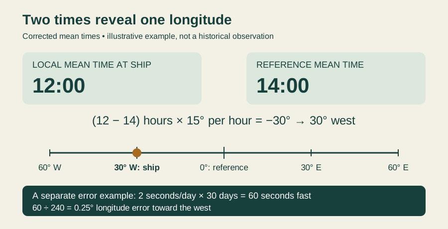
Imagine a ship where local mean time is noon while reference time is 2 pm. The ship’s time is two hours behind, so it lies 30 degrees west of the reference. The subtraction is easy. Obtaining two trustworthy times in the middle of an ocean was not.
Why governments cared
Bad navigation endangered lives and made voyages longer and less predictable. Better positioning also served trade, naval power and overseas expansion; this was not a research programme detached from political ambition.
Spain offered a longitude incentive in 1567, followed by other governments. Britain’s Longitude Act received royal assent on 9 July 1714, establishing substantial rewards, with £20,000 as the highest prize. The problem had become a public challenge rather than merely a private puzzle. The museum traces those incentives and their stakes.
Carrying another place’s time
John Harrison, a carpenter and self-taught clockmaker, pursued the possibility of carrying reference time aboard ship. His early sea clocks were not a smooth procession of successes. H2 had a fundamental flaw; he began H3 in 1740 and spent nineteen years on it without obtaining the required accuracy.
The decisive change was toward a watch-sized instrument, H4. Harrison’s son William took it to Jamaica for a trial in 1761. A further trial to Barbados followed in 1764. In 1765, the Commissioners agreed that its performance met the most demanding accuracy requirements of the 1714 Act.
Success in a trial was not the same as a widely available solution. Payments were tied to disclosing the mechanism and demonstrating that other makers could reproduce its performance. Those conditions contributed to bitter disputes. The museum’s account of Harrison’s timekeepers makes clear why the story cannot end with an ingenious object simply being unveiled.
The Sun is not a perfectly uniform clock
There is a subtlety in our noon example. A clock keeps mean time, based on an average solar day. The actual Sun does not cross the same north–south line at exactly equal intervals throughout the year. Observed solar time therefore needs a correction before it can be compared directly with a mean-time clock.
Flamsteed published conversion tables in the early 1670s. This distinction between apparent and mean time was part of the supporting knowledge behind navigation, not a minor technical afterthought. Our diagram deliberately assumes that the correction has already been made. The museum explains mean time and includes its Harrison’s Timekeepers video.
Astronomy remained in the story
A clock was not the only way to obtain reference time. In lunar-distance methods, navigators measured the angle between the Moon and a star or the Sun. They compared it with tables showing the expected angle at different reference times. The matching angle told them the reference time. The sky could supply the time information that a marine timekeeper carried mechanically.
Nevil Maskelyne helped turn this approach into a usable system. The Nautical Almanac’s data for 1767 were ready for printing by the end of 1766. Its production depended on people performing lengthy calculations, including Mary Edwards, one of the women who worked as a human “computer”.
This was not a contest in which astronomy became useless when a clock worked. Timekeepers remained expensive and their reliability took time to establish; astronomical methods demanded skill. Navigators could combine techniques with dead reckoning, the traditional estimate based on a vessel’s movements. The history of Maskelyne and the lunar method restores these less theatrical contributions.
When seconds become distance
The interactive model below asks a narrower question: what if an otherwise correct reference clock has a small, uncorrected daily gain? A known, stable rate can be allowed for. Here the model keeps only the error left after any correction.
At two seconds gained per day, thirty days produce a clock reading one minute fast. From the time–angle relationship above, that implies a quarter-degree longitude error. Because the reference reading is too large, the inferred position shifts west. A slow clock reverses the direction.
From an angle to kilometres
The same angular mistake spans fewer kilometres at higher latitudes because circles of latitude become smaller. Changing latitude does not repair the clock; it changes the distance represented by the error.
A shared reference, not a final invention
In 1884, an international conference in Washington selected Greenwich as the common prime meridian. Its existing use in navigation helped make it the practical choice. The history of the prime meridian reminds us that longitude required agreement as well as measurement.
The achievement was larger than a watch and less sudden than a discovery headline. Observations, calculations, instruments, tests and common conventions turned a comparison of times into something sailors could trust. Knowing where you were depended, unexpectedly, on preserving a reliable connection to somewhere else.
EXPLORE THE IDEA
When a clock error becomes a position error
Positive gain means a fast reference clock; negative gain means a slow one.
60.0 sAccumulated clock error
0.250° westLongitude error
27.8 kmDistance along latitude circle
Try 60° latitude: the distance halves, but the angular error stays the same. Set the gain to zero to remove this source of error.
Scroll the diagram sideways to see every label.
Illustrative inputs, not voyage measurements. Constant uncorrected residual clock gain; local mean time is assumed correct. Distance is along a latitude circle on a sphere of radius 6,371 km. Excludes observation errors, weather, varying clock rate and Earth’s non-spherical shape. Not a navigation tool.
YOUR PERSPECTIVE
Join the discussion
What surprised you? Have a question or a correction? Share your thinking.
No comments yet. Start the conversation.
Sign in with ChatGPT to commentAnyone can read the discussion. Sign-in helps limit spam.