
A compass needle on a quiet table seems to be answering a fixed instruction. Turn the case and the needle swings back. Yet the north it seeks is not supplied by a permanent magnet locked inside Earth. Its source is a restless ocean of metal, hidden beneath almost 2,900 kilometres of rock.
That contrast is the key to the planet's magnetic field. The pattern around Earth is fairly orderly at large scales, but the machine sustaining it is moving, uneven and capable of changing its mind.
From a magnetic Earth to a measured field
People used magnetised needles for navigation long before they understood why they worked. In 1600, the English physician William Gilbert argued in De Magnete that Earth itself behaved like a great magnet. His small spherical magnet, or terrella, reproduced features of a compass around a globe. It was a powerful model, but it did not reveal the deep source.
The science advanced when observations became comparable. Carl Friedrich Gauss developed a method for measuring magnetic intensity in absolute units in the 1830s, helping turn scattered compass directions into a quantitative global field. A peer-reviewed history of geomagnetism traces the path from early compasses through Gilbert and Gauss.
Measurements established that Earth's field is broadly dipolar, meaning it has a two-pole pattern: from far away, it resembles the field of a bar magnet tilted relative to the rotation axis. But “Earth is a bar magnet” is a description of the outside pattern, not an explanation of the generator.
Permanent magnetism cannot do the job in the deep interior. Temperatures in the core are too high for ordinary iron to retain the organised magnetic domains, small regions with matching magnetic directions, found in a refrigerator magnet. Something must continually regenerate the field.
The dynamo chain
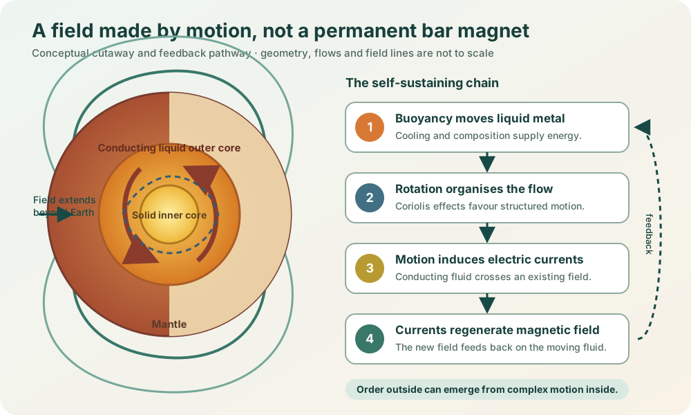
Earth's outer core is a layer of electrically conducting liquid metal, mainly an iron alloy, a mixture of iron and other elements. The inner core is solid, while the mantle above the outer core is solid rock that flows only over geological time. The magnetic generator operates in the liquid layer.
The depth is measured inward from the surface, not across the whole planet. Earth's mean diameter is about 12,742 km, so the surface-to-centre distance, or radius, is about 6,371 km. The outer core begins roughly 2,900 km below the surface, still well short of the centre. Subtracting that depth from the radius puts its upper boundary about 3,470 km from the centre; the values are rounded. NASA's Earth fact sheet lists the mean radius and core radius. “Liquid core” therefore describes a particular metal layer inside Earth, not an entirely molten planet.
The process is called the geodynamo. In compact form, it is a feedback loop:
1. Heat and differences in composition make some liquid less dense than the liquid around it. It rises, driving motion in the conducting outer core. 2. Earth's rotation helps organise that motion into structured, twisting flows. 3. Moving conducting fluid through an existing magnetic field induces electric currents. 4. Those currents create magnetic fields that can reinforce and reshape the original field.
Some magnetic energy is continually lost as heat. If the moving liquid regenerates the field fast enough to replace that loss, the dynamo keeps working. The NASA Goddard geodynamo programme describes convection driven mainly by the planet's cooling and differentiation. As the inner core grows, light elements are released into the liquid above, making parts of the liquid less dense. This helps drive rising motion, alongside the effects of heat.
Rotation matters, but it is not a battery. The energy ultimately comes from Earth's thermal and compositional evolution. Rotation curves and organises the flow through the Coriolis effect, the change in moving fluid’s path seen from a rotating planet. The Institut de Physique du Globe de Paris explains the feedback between fluid motion, electric current and field.
A little deeper: why computer models are difficult
A dipole is the first approximation, not the whole map
Near the surface, the main field is often approximated by a tilted dipole. That simple geometry explains why a freely suspended compass needle tends to lie nearly horizontal around the magnetic equator and dip more steeply at high magnetic latitudes.
The real field has important departures from that ideal. Magnetised rocks in the crust add local structure. Electric currents in the ionosphere and magnetosphere add variations that can change quickly during space weather. The British Geological Survey separates these sources and reports surface strengths of roughly 22,000 to 67,000 nanotesla.
This is why “magnetic north” is not one universal correction printed forever on a map. Declination, the horizontal angle between magnetic and true north, depends on place and time. Inclination, or dip, is the angle at which the field points into or out of the ground. Total strength varies too.
The interactive model below isolates only the centred axial-dipole geometry. It shows the clean trend that the real field complicates.
The field carries news from an unreachable place
No instrument has visited the core. Scientists infer its behaviour from the field outside it. Ground observatories continuously measure the field’s direction and strength. A typical USGS station uses one instrument to measure three perpendicular components of the field and another to measure its overall strength. The first is a tri-axial fluxgate magnetometer. USGS describes that observing system.
Satellites add global coverage. ESA's three-satellite Swarm mission separates signals from the core, crust, oceans, ionosphere and magnetosphere. Repeated measurements reveal secular variation: slow changes in the main field over years and decades, driven by evolving core flow.
Those changes are practical, not merely academic. NOAA and BGS update the World Magnetic Model every five years for navigation and heading systems. The current WMM2025 is intended for 2025 through late 2029. A phone's compass may look immediate, but accurate magnetic heading depends on a dated model of a moving planet.
Reversals are real, but not a clock
Rocks preserve another archive. When some lavas cool or sediments settle, magnetic minerals can record the surrounding field. These records show that the dominant polarity has reversed many times. The intervals are irregular; a decline in one component today is not a timetable for the next reversal.
During a reversal, the field would not simply switch off everywhere and restart backwards. Models and rock records point to a more complex transition with several magnetic poles rather than one simple north–south pair. Nor does a compass point directly to a single geophysical “pole” in every location; local direction comes from the whole field around it.
A quiet compass reads a changing system deep inside Earth. Liquid metal circulates, electric currents build magnetic fields, and those fields affect the flow. Earth continually regenerates its magnetism.
EXPLORE THE IDEA
How would an ideal dipole tilt a compass?
0.0°Ideal inclination
1.00×Equatorial strength
Move away from the magnetic equator. In this ideal geometry the needle tilts more steeply and the total field grows. Earth’s measured field departs from this clean pattern.
Scroll the diagram sideways to see every label.
Centred axial-dipole teaching model at Earth’s surface. Magnetic latitude is not geographic latitude. Inclination uses tan(I) = 2 tan(latitude); strength is normalised to the model’s equator. It omits dipole tilt, longitude, altitude, crustal magnetism, space-weather currents and secular change. It is not a navigation model. No animation.
YOUR PERSPECTIVE
Join the discussion
What surprised you? Have a question or a correction? Share your thinking.
No comments yet. Start the conversation.
Sign in with ChatGPT to commentAnyone can read the discussion. Sign-in helps limit spam.