
A ship in deep water may pass over a tsunami without meeting a towering wall. Hours later, the same event can send destructive currents through a harbour and water across streets. This apparent contradiction disappears when we stop judging a wave only by its height.
A tsunami is a series of extremely long waves produced by a sudden displacement of a large volume of water. Most are associated with earthquakes beneath or near the ocean, although landslides, volcanic activity and some atmospheric disturbances can also generate them. NOAA's overview begins with this defining displacement rather than with the popular image of a single breaker.
A moving seabed moves the water above it
Imagine a broad area of seafloor shifting vertically during an earthquake. The water above that area is pushed out of place. Its surface cannot stay flat while the seabed suddenly moves. Gravity begins restoring the disturbed surface, and the disturbance spreads outward. The event launches energy in more than one direction and usually creates a train of waves, not one isolated pulse.
This is why earthquake magnitude alone is not a complete tsunami detector. The earthquake’s location and depth matter, as do the way rocks move along the fault and how much the seabed changes shape. An earthquake can shake strongly without displacing enough water in the right way. Conversely, a submarine landslide can push water rapidly even though its source is not the same kind of fault rupture. The US Geological Survey explains the range of sources.
The phrase “tidal wave” is misleading. Tides are driven mainly by the gravitational relationships among Earth, Moon and Sun. A tsunami has a different source and timescale, even though both alter coastal water level. Our article on tides follows that slower astronomical mechanism.
The whole water column participates
Wind waves mainly involve motion near the surface. Their familiar crests may be close enough together that water depth in the open ocean is large compared with their wavelength, the distance between successive wave crests. A tsunami can have a wavelength of hundreds of kilometres. Even an ocean several kilometres deep is shallow relative to such a wave.
In this shallow-water regime, the disturbance involves essentially the full depth of the water column. “Shallow” describes the ratio of depth to wavelength, not a beach. That is the first reason a tsunami behaves unlike an ordinary wind wave.
A long disturbance involves the full water depth
A broad source moves water
A seabed change launches a disturbance, not just a surface splash
Deep water can still be “shallow”
The depth is small compared with the enormous wavelength
Shallower water reshapes the wave
The disturbance slows and the crests become closer together
Orange arrow: seabed displacement. Single arrow: disturbance propagation. Paired arrows at several depths: local water motion. Dashed line: reference water level
Qualitative cross-sections, not to scale or measurements of one event. Relative heights and spacing are exaggerated. This is not an arrival-time, flooding or safety forecast; the first arrival need not be the largest.
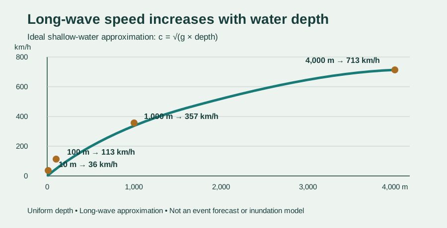
It also explains the speed. For an ideal long wave, speed is approximately the square root of gravitational acceleration multiplied by water depth. In four-kilometre-deep water, that gives about 198 metres per second, or 713 kilometres per hour. NOAA's propagation guide presents the same depth-dependent relationship.
The speed is not a fixed property carried by the wave from its source. A tsunami crossing an ocean basin continually responds to changing bathymetry, the shape and depth of the seafloor. Different parts can refract, or change direction, because they encounter different depths.
Why deep-ocean height can be deceptive
Fast does not necessarily mean tall. In deep water, the energy is distributed through a very long wave whose surface height may be modest. Its enormous wavelength and long period, the time between passing crests, allow a large volume of moving water to carry substantial energy without resembling a cinematic wall.
Near shore, depth decreases and the long wave slows. Its wavelength shortens. The transfer of energy into shallower water can increase wave height and strengthen currents, a transformation called shoaling. The shape of the coast and seabed can concentrate or spread the moving water, so neighbouring places may experience very different effects.
The result does not always arrive as a curling breaker. It may resemble a rapid flood, a turbulent surge or an unusual withdrawal followed by advancing water. Harbours can amplify currents, and successive waves may continue for hours. The first arrival need not be the largest.
Explore the long-wave model
Measuring a wave that is hard to see
Earthquake instruments can rapidly locate and estimate a rupture, but sea-level observations test what the ocean is actually doing. NOAA's Deep-ocean Assessment and Reporting of Tsunamis system, known as DART, uses a bottom pressure recorder. A link using sound sends information to a surface buoy, which relays it by satellite. NOAA describes the measurement chain.
Pressure at the seabed responds to the water above. Detecting a tsunami therefore does not require a camera to see a crest in the open ocean. The measurement can be combined with earthquake information and numerical models to update forecasts. Coastal water-level stations then add observations nearer shore.
A warning system is larger than its sensors. UNESCO-IOC describes an end-to-end chain extending from detection and forecast through national messages to a prepared community that can respond. After the Indian Ocean disaster of 2004, international warning and mitigation arrangements expanded across ocean basins. The UNESCO-IOC history shows why communication and preparedness belong beside instrumentation.
When nature is the first warning
A nearby tsunami can arrive before a distant warning network has much time to act. Natural signs include strong or long ground shaking, an unusual rapid rise or fall of the sea, or a loud roar from the ocean. If you are near a coast and observe a natural warning, move immediately to high ground or inland and follow local evacuation instructions. Do not go to the shore to investigate, and do not return until authorities give the all-clear. NOAA Ocean Today provides official warning-sign guidance.
The crucial insight is that a tsunami is not simply a larger version of the wave that lifts a surfboard. It begins by moving a broad region of water, sets water moving through essentially the full ocean depth, races according to that depth and transforms as the seafloor rises beneath it. The surface is only the part we can see. The scale of the moving water below is what makes the event extraordinary.
EXPLORE THE IDEA
How does water depth change a tsunami's motion?
713 km/hIdeal wave speed
1.40 h1,000 km travel time
238 kmWavelength at 20 min
As depth decreases, the ideal long wave slows. This model deliberately does not infer how tall the water becomes near shore.
Scroll the diagram sideways to see every label.
Ideal long-wave model: c = √(g h), using g = 9.81 m/s² and uniform depth h. Travel distance is fixed at 1,000 km; wavelength uses an illustrative 20-minute period. It does not calculate wave height, arrival time for a real coast, flooding or safety. Bathymetry, source shape, friction, dispersion and coastal geometry are omitted. No animation.
YOUR PERSPECTIVE
Join the discussion
What surprised you? Have a question or a correction? Share your thinking.
No comments yet. Start the conversation.
Sign in with ChatGPT to commentAnyone can read the discussion. Sign-in helps limit spam.