
Two places can sit at nearly the same latitude, receive strong sunlight and still experience very different amounts of lightning. One may hear thunder only occasionally. Another may watch storms return night after night in the same season.
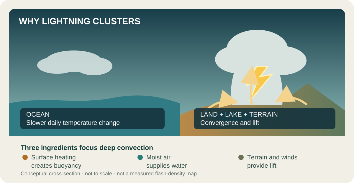
Latitude alone cannot explain lightning patterns. Storms need moisture, unstable air and lift strong enough to form tall clouds where ice particles collide. Coastlines, mountains, lakes, winds and daily heating control where these ingredients meet.
The flash begins with a rising column
The electrical machinery inside a storm is described in Before the flash: how a storm builds lightning. In brief, an updraft, a rising current of air, carries small ice crystals upward. Heavier graupel, soft pellets of ice formed when droplets freeze onto snow crystals, tends to remain lower. Collisions transfer charge, and the storm sorts the charged particles into different regions.
That process needs a vigorous mixed-phase cloud: one containing liquid droplets and ice. A useful weather shorthand is moisture, instability and lift. Moisture supplies water. Instability means that an air parcel, once lifted, can remain warmer and less dense than its surroundings and keep rising. Lift provides the initial push upward. It can also come from convergence, where winds meet and force air to rise. The National Weather Service describes how updrafts, ice crystals and graupel help separate charge.
These are necessary ingredients, not a simple recipe. Wind shear, changes in wind speed or direction with height, also matters. So do the height where water starts to freeze and the cloud’s internal structure. Together they influence how many flashes a storm produces. Counting warm, humid days alone will not predict lightning.
Why land usually outshines ocean
Land changes temperature faster than the ocean. On a sunny day, a land surface can heat the air immediately above it, increasing buoyancy and helping afternoon clouds grow vertically. The ocean mixes heat through a larger volume and loses energy through evaporation, so its surface temperature usually changes more slowly through the day.
This difference helps explain a broad global pattern. In a satellite study of lightning patterns over 16 years, concentrated lightning activity was more common over land, while continental activity generally peaked in the afternoon. NASA's account of the study describes the land–ocean contrast.
That does not mean oceans lack dangerous thunderstorms. Tropical cyclones, convergence zones and marine squall lines can contain intense lightning. “Less on average” is not “safe,” and a climate map cannot describe the risk from the storm overhead.
Mountains and lakes can focus the ingredients
Terrain forces moving air upward. Slopes also create local wind systems as land heats by day and cools by night. Around large tropical lakes, lake breezes, mountain breezes and moist air can converge repeatedly in the same region. The landscape does not manufacture electric charge; it organizes the weather that builds charge inside clouds.
Lake Maracaibo in Venezuela is a striking example. A study published in 2016 used 16 years of observations from the Lightning Imaging Sensor on NASA's Tropical Rainfall Measuring Mission. Within that particular dataset and analysis, the lake region averaged about 233 flashes per square kilometre per year. Storms commonly formed at night when mountain breezes converged over warm, moist lake air. NASA reported an average of 297 nighttime thunderstorms per year, with a September peak, for the study period.
Those figures describe patterns during the study period. They are not a ranking that must remain true forever. Rankings depend on the years observed, the area of each grid cell, detection efficiency and the definition of a flash. A later instrument or different method can produce a different order without either result being dishonest.
The same study found six of its ten leading hotspots in Africa, with several near Lake Victoria and other lakes of the East African Rift. The pattern matters: tropical moisture, complex terrain and converging local winds can make particular lake districts reliable storm factories.
A useful distinction: weather-maker, not lightning magnet
The hotspots move with the seasons
The most active belt is not fixed. Solar heating and tropical rain belts migrate north and south through the year. Monsoons change wind direction and moisture supply. Soil moisture, vegetation, sea-surface temperature and large-scale circulation alter where air rises far enough to form tall storm clouds. This strong upward movement is called deep convection.
Even the daily clock varies. Many continental storms grow after daytime heating, while some lake-and-mountain systems intensify at night as slopes cool and breezes converge over relatively warm water. A monthly map therefore tells a different story from an annual average, and a local evening forecast tells a different story again.
This is also why “a warmer world means more lightning everywhere” is too simple. Warming can affect moisture, instability, cloud depth and circulation, but those influences need not change together or in the same direction in every region. Projections must specify the location, season and lightning metric rather than scaling one global number.
Seeing flashes from above
Ground networks are excellent for many regional uses, but their sensor spacing and detection methods differ, and coverage over oceans is limited. Space-based optical instruments made it possible to compare broad regions with a more consistent view.
The Lightning Imaging Sensor detects brief changes in light at cloud tops, including lightning within a cloud (intracloud) and lightning between a cloud and the ground. Its narrow band around 777 nanometres lies in the near-infrared and helps isolate lightning signals even during daylight. The older tropical-orbit mission supplied the 16-year hotspot study; a later LIS operated on the International Space Station. NASA's 2017–2023 visualization uses the final quality-controlled ISS-LIS dataset and lets the seasonal migration appear as moving clusters rather than permanent dots.
Explore a storm environment
A map is not a shelter decision
Living outside a climatological hotspot does not make an individual thunderstorm harmless. If thunder is audible, lightning is close enough to be dangerous. Move immediately into a substantial building or an enclosed metal-topped vehicle, and follow National Weather Service lightning-safety guidance. Do not use a phone map, a flash count or the model below to decide that remaining outdoors is safe.
The uneven distribution of lightning is therefore not a collection of mysterious favoured places. It is weather meeting landscape. Sunlight loads energy into the lower atmosphere, water releases stored energy when vapour condenses into droplets, called latent heat, and winds and terrain decide where air is gathered and lifted. For an instant, a flash reveals the electrical result. Over years, the pattern of those flashes reveals the hidden geography of rising air.
EXPLORE THE IDEA
What happens when one storm ingredient changes?
Set any one control to zero: the product becomes zero. Restoring only that ingredient raises the score without claiming that lightning must occur.
Scroll the diagram sideways to see every label.
Illustrative ingredient index = 100 × normalized heating × normalized moisture × normalized organized lift. The inputs are teaching proxies, not observations. The score is not flash density, strike probability or a forecast. It omits shear, entrainment, freezing-level height, cloud microphysics, aerosols, storm duration and regional calibration; no animation.
YOUR PERSPECTIVE
Join the discussion
What surprised you? Have a question or a correction? Share your thinking.
No comments yet. Start the conversation.
Sign in with ChatGPT to commentAnyone can read the discussion. Sign-in helps limit spam.