
A thunderstorm seems to end at the top of its cloud. Above that boundary, the sky may look empty. Yet sensitive cameras sometimes reveal another set of electrical flashes. A red figure branches far above the storm. A blue cone rises from the cloud top, then almost immediately disappears.
These are called transient luminous events, or TLEs. “Transient” is literal. Many last for only milliseconds, thousandths of a second, which helps explain why people reported them long before instruments supplied convincing evidence. They also occur above the brilliant lightning and obscuring cloud that produced them. The familiar bolt is therefore only one part of a taller electrical system.
A discovery made by accident
Pilots had described strange lights over storms, and written reports reach back centuries. But a report that cannot be measured or repeated is difficult to place within science. That changed on 6 July 1989, when researchers at the University of Minnesota were testing a low-light camera for a rocket experiment. The camera happened to be aimed toward a distant storm and recorded two faint columns above it.
Space Shuttle video from 1989 to 1991 supplied more examples, turning the accidental recording into a new research field. NASA Earthdata reconstructs how the ground camera and Shuttle tapes established the phenomenon.
The name sprite was chosen partly because the event was so elusive. Other playful names followed, including elves and trolls. The names distinguish different shapes, heights and electrical processes.
A sprite is a response above the storm
A sprite does not usually grow continuously out of a cloud like an ordinary bolt. It forms much higher, commonly around 80 kilometres above the surface, after a powerful lightning discharge below. NASA's Spritacular project describes sprites as brief upper-atmosphere flashes that can combine diffuse glows with bright tendrils.
Many sprites follow strong positive cloud-to-ground lightning, in which positive charge is transferred toward the ground. The lightning rapidly rearranges a large amount of charge inside the storm. That change creates an electric field above the cloud. In the thin upper atmosphere, the field can accelerate electrons and begin an electrical breakdown: normally insulating air becomes temporarily conductive.
The accelerated electrons transfer energy to nitrogen molecules in collisions. As those molecules release some of that energy as light, much of the red glow appears. The branching structures seen in detailed images are built from narrow, rapidly developing channels called streamers. A photograph may make a sprite look like a stationary jellyfish, but it records a process developing too quickly for an unaided eye to follow.
Association is not inevitability. Not every positive flash makes a sprite, and important questions remain about why one storm produces a particular shape while another does not. NASA lists sprite frequency, initiation conditions and effects on the global electrical circuit among the questions still being studied. The Great Sprites Chase explains both the established mechanism and those uncertainties.
A blue jet begins in a different place
A blue jet starts near the top of a thundercloud and travels upward, usually into the stratosphere, the atmospheric layer above the main weather layer. Its shape can resemble a narrow cone or fan. The colour comes from emissions in nitrogen that favour blue and near-ultraviolet wavelengths (just beyond the violet end of visible light) under the conditions lower in the atmosphere.
That geometry matters. A sprite is an upper-atmosphere response to a major charge change below; a blue jet is an upward discharge emerging from the storm region itself. Lumping both together as “upward lightning” hides the distinction.
A field-triggered response and an upward discharge
Sprite: a response high above the cloud
1. Storm charge changes: a powerful cloud-to-ground discharge rapidly transfers charge, often positive charge
2. The upper-air field changes: the transient field can accelerate electrons and initiate local electrical breakdown in the thin air well above the cloud
3. That air emits light: electrons transfer energy to nitrogen molecules, whose emission gives much of the red glow. Rapidly developing discharge channels form the streamers
The red structure is separate from the groundward lightning channel, with a gap above the cloud
Blue jet: a discharge from near cloud top
Start near the cloud top: electrical breakdown begins in the storm-top region
Propagate upward: ionising discharge channels develop upward and spread into a cone or fan in the stratosphere
The solid blue arrow shows upward development of the discharge front, not a speed, material jet or guarantee that it reaches the ionosphere
Left: the dashed arrow links the storm’s charge change to the outlined upper-air field region; red lines represent local sprite discharge. Right: blue branches begin at the cloud top. The solid blue arrow indicates upward propagation
Use the existing altitude explorer below for broad atmospheric layers and event ranges. This comparison adds the causal distinction without treating a boundary as a hard lid
Two separate conceptual cases, not simultaneous events and not to scale or measurements of one storm. The dashed arrow is a causal link, not an electric-field line or conductive channel. Many sprites follow strong positive cloud-to-ground flashes, but not every such flash produces one. Initiation conditions and shapes remain under study. Height alone does not classify an event, and the existing altitude explorer does not calculate breakdown or predict events. A blue jet is not a gigantic jet reaching the lower ionosphere.
Sources: NASA: charge change, upper-air field and sprite light; ESA: blue jets from cloud tops into the stratosphere; Neubert et al.: observed blue-jet onset and remaining uncertainties
Scientists also observe gigantic jets, which can bridge a thundercloud toward the lower ionosphere, a region containing many electrically charged particles, and extend much farther than an ordinary blue jet. The categories describe observed patterns. How jets begin, and how they relate to ordinary lightning and storm charge, remain active research questions. A 2025 observation from the International Space Station, initially mistaken for a sprite, was later identified as a gigantic jet, showing why position and development matter more than a dramatic still image. NASA compares that event directly with a sprite.
A little deeper: why altitude changes the discharge
One storm, several atmospheric layers
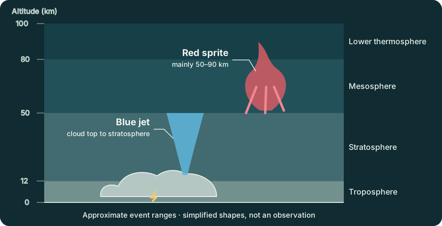
Most weather occupies the troposphere. NASA places its average top near 12 kilometres, although towering thunderclouds can push into the lowest stratosphere. The stratosphere extends to roughly 50 kilometres, the mesosphere to roughly 80 kilometres, and the thermosphere begins above that. NASA's atmosphere guide gives these approximate boundaries.
Blue jets inhabit mainly the gap between cloud tops and the upper stratosphere. Sprites occupy much of the mesosphere and may extend across a broad altitude range. The separation explains a useful visual clue: a dark gap can lie between the bright storm and the red sprite above it.
The boundaries in textbooks are not hard lids. Atmospheric layers are defined largely by how temperature changes with height, and their transition altitudes vary. Likewise, a TLE is not assigned a name by altitude alone. Shape, colour, development and its relationship to the parent lightning all contribute.
Explore the vertical scale
Seeing what the cloud conceals
Ground observers need a distant storm, a clear view above it and a sensitive camera. Even then, the flash can fit within a single frame. Looking from above changes the geometry. Astronauts and instruments on the International Space Station can see storm tops and the atmosphere above them without the lower cloud blocking the view.
ESA experiments have used that vantage point to examine sprites, jets and other energetic events. The agency notes that sprites can reach about 90 kilometres and may last no more than a few tens of milliseconds. ESA's account of observing thunderstorms from orbit also explains why fast cameras and careful timing are essential.
There is a safety lesson in the distance required for observation. TLE research is not a reason to stand beneath a thunderstorm with a camera. If thunder is audible, the storm is close enough to threaten you with ordinary lightning; move to a substantial building or an enclosed metal-topped vehicle and follow official local guidance. The spectacular event is high above the cloud, but the immediate hazard remains at ground level.
A cloud that ends near the tropopause, the boundary above the main weather layer, can disturb air tens of kilometres higher. A sensitive camera pointed at a familiar storm revealed that the apparently empty darkness above it was active too.
EXPLORE THE IDEA
Where above a storm are you looking?
Move across 50 km: the model changes atmospheric layer and shifts from the blue-jet band to the sprite band. That boundary is approximate, not a physical wall.
Scroll the diagram sideways to see every label.
Altitude explorer using simplified boundaries: troposphere below 12 km, stratosphere 12–50 km, mesosphere 50–80 km and lower thermosphere above 80 km. Event bands are broad teaching ranges: storm top 12–18 km, blue jets 15–50 km, sprites 50–90 km. Boundaries and events vary. This is not measured storm data, an event classifier or a breakdown calculation; no animation.
YOUR PERSPECTIVE
Join the discussion
What surprised you? Have a question or a correction? Share your thinking.
No comments yet. Start the conversation.
Sign in with ChatGPT to commentAnyone can read the discussion. Sign-in helps limit spam.